After an incredible seven month sojourn in French Polynesia, the time had come to leave this South Pacific paradise and venture north to Hawaii. This destination was not on our original plan, but with so few countries and islands west of French Polynesia open, and cyclone season now in full swing, it was the prudent move and would give us the chance to see a part of the US neither of us had visited before. The passage from the Marquesas to Hawaii is around 2000 nautical miles on a heading of about NNW crossing the equator from summer to winter. The trade winds, both north and south of the equator are largely from the east, south east below and more north east above the Inter Tropical Convergence Zone (ITCZ). This means it should be possible to sail all the way on either a beam reach or worst case a close haul.
We had been watching the weather on the passage line for a couple of weeks, and had never really seen an unfavourable situation - the winds were as mentioned above, and around 15-25 knots more or less all the way. The passage time estimates were about 12-14 days. So having picked a departure date - Thursday 26th November - Thanksgiving Day in the US, we spent the last few days in Nuku Hiva on last minute provisioning, a tour of the island and boat checks and preparation. It's wise to check all the lines and rigging before a passage so I found myself hoisted up the mast the day before leaving to check all was well. Unexpectedly I found a couple of small issues that required some attention - there was a small line chafe close to the top of the main halyard which hoists the mainsail, and the aluminium extrusion which holds the Genoa sail had slipped again and caused the top swivel to dislodge at a weird angle. The question was - do we try to correct these before leaving, or are they minor enough that we can wait until we arrive in Hawaii? After much consideration of the risks and potential consequences, we decided to stay with the plan (and hope for the best!!). 8am on Thanksgiving Day saw us weighing anchor for the last time in French Polynesia as we slowly motored out of Tahoie bay towards the southern coast of Nuku Hiva. We would make our way west along the southern coast and then north past the west end of the island to pick up the winds once clear of the island mass. After a couple of hours, and exactly as expected, the easterly winds hit us with a vengeance and we were off! The sun was shining, the sails were full and open sea ahead of us beckoned as we mentally prepared for the next two weeks at sea.
Towards the end of the afternoon, as we were approaching the most northern and largely uninhabited islands of the Marquesas we heard the fishing line scream! After a short but energetic fight we landed a beautiful Mahi-Mahi with its iridescent colours of blue and yellow flashing in the lowering sunlight. This was the biggest Mahi we had landed yet, and it made enough delicate white flesh for six meals - a great start to our passage! As we passed the northern islands and off into the great Pacific once more, we continued to make fast speeds with the wind consistently blowing 20 knots on a close haul. The moon was becoming full, which is a huge bonus on these longer passages as one can see much more at night and especially with bigger seas, it makes for a more comfortable ride. That first night passed uneventfully and by 8am the next morning we found we had covered almost 200 miles, which is an average speed of 8 knots. The following day, and subsequent four days, were the same - mostly sunny, 15-20 knots of wind on a beam or close haul and anywhere between 175 and 200 miles travelled. We crossed the equator on day four, Sunday, and as always shared a tot with Neptune in the hope of securing safe passage for us and india. During the afternoon we had enjoyed a huge pod of dolphins swimming with us, jumping and playing as if happy to see another soul in this remote ocean. Shortly after they left the fishing line screamed again, and with a bang went quiet...I pulled the line in to find the whole lure and stainless steel leader had disappeared. It could have been a large shark but we were hoping one of the dolphins hadn't mistakenly took the lure - it would be unusual as they are normally too clever for that. Once when sailing in the Marquesas we had a not-so-smart booby who was following the boat take the lure and got the hook stuck in his beak. Not at all what we want to catch!
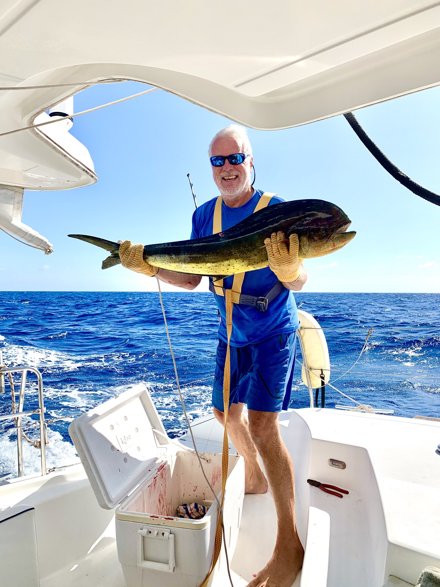
The first of our two Mahi...
 |
| The moment we crossed the equator |
We had used the Code zero sail on and off over these first few days if the wind dropped a little, and it proved again to be very effective in the right conditions. On day five we had a slight issue when furling the Code zero as the wind picked up, when it tangled on itself and jammed in such a way that we knew it would be difficult to unfurl again. When such things happen on a day trip or shorter passage, it's fine to wait until anchored to pull it down and do whatever is needed to resolve the jam, but when one is making relentless progress in big seas, everything becomes 10 times more difficult, and dangerous. So with the waves breaking over the bows, I headed up front to drop the whole Code zero sail and torsion line onto the trampoline and try to figure out how to unjam it. Well, it stayed like that overnight until the following morning when the wind again dropped enough for us to hoist it once more, and play around with alternately the sheets and the furler, back and forth, until at last the wind caught in the tangle and blew it free. We were off again! Little did we know these were the last days we would see our striking blue Code zero in all its glory...
By day six we had still not quite reached the ITCZ, as it was sitting quite far north (around 5-6 degrees N) at these longitudes, and enjoyed our last day of comfort and leisurely sailing, as it transpired. Day seven, Wednesday, dawned with light winds and some small squalls. We chose to fly the Code zero and luckily passed some squalls without major wind increase as the day drew on. During the afternoon we again heard the fishing line scream, and as I started to reel in whatever surprise was hooked, I knew it was big, the pull was enormous. These days we can usually tell by the behaviour of the catch what it is before we see it. Tuna tend to dive down deep and pull all the way, they are super strong. Wahoo stay near the surface and don't fight much as you reel them in. Mahi-Mahi also stay on the surface and you may or may not get a glimpse of their vivid colours as they jump and squirm. Ten minutes of quite a fight, and then close to the boat it jumped a little and we could see it was a huge Mahi. Right up close as we are preparing to gaff the fish, we start to execute the plan - harness for me, attached to the lifeline, I step down the rear steps to be close to the water, Dara hands me the gaff and I try to gaff the fish before it comes to life and wriggles free. We have lost so many huge fish in these final stages as we perfected our technique, but this was not about to be the one that got away! Sure enough it may have been the largest Mahi we had seen, a huge bull (male with the large protruding 'forehead'). It was so big I could barely lift it up for a photo, but it was easily almost five feet long and more than 60 lbs. It made ten more delicious meals, straight into the freezer.
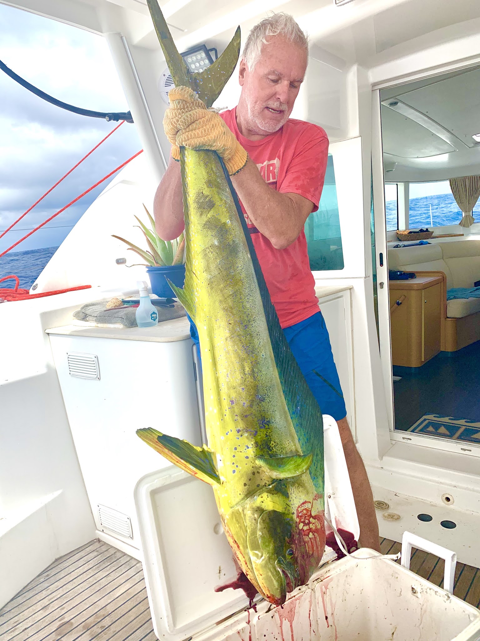 |
| Monster Mahi! |
As dusk fell and the last vestiges of sunlight disappeared in the east, we saw what appeared to be a large squall on the horizon ahead of us. We were still flying the code zero, and had passed through one or two smaller squalls without significant wind increase during the day, so were hopeful this was the same. Within what seemed like only minutes, the squall was upon us, and it suddenly became dark all around, the rain started falling and the wind increased. We knew right then it was a mistake to have left the Code zero up for the night, and as went on deck to consider it, we arrived just in time to see the huge sail explode in a tickertape of blue nylon as the wind hit 30 knots. Nothing to do except secure the remnants of the sail and turn on the engines. Luckily with no other sails up, we were able to weather the storm as the seas and wind built over the next two hours. You probably haven't really sailed until you have spent time in the pitch black darkness, thousands of miles from anywhere, being tossed around in 12 foot seas and 40 knot winds, with little control over the boat, for a couple of hours. This storm (way more than a squall) seemed to follow us as we tried to make some progress north away from it. the ITCZ is either deadly calm - the doldrums - or frighteningly stormy, so we knew we were in for a long night. Also we knew the 'zone' stretched at least 150 miles north of us, so we likely had 24 hours of this to look forward to. As it happened, that big first storm was the worst of it, and after we had come through that, we had only some rough seas and more heavy squalls to worry about. By day break it all looked better anyway and we continued motoring northwards, hoping to pick up the northern hemisphere weather system of NE trade winds soon. Slowly but surely, conditions improved and by nightfall, 24 hours after that big storm, we started to feel the steadily increasing NE winds. I have to say, india, as always, proved a worthy adversary for the conditions and not once did we feel unsafe or in any danger.
And so the trade winds had thankfully arrived, but be careful what you ask for. We were now 800 miles from Hawaii, and these winds would be the predominant conditions all the way there. Our weather predictions had forecast 15-20 knot winds, but these were 20 knot +, and right at a close haul wind angle, which usually is our fastest point of sail. That meant we were moving at quite a rate of speed, anywhere between 8 and 10 knots, often more, together with 9 feet waves coming at a 45 degree angle to our heading. All this makes for a thrilling and uncomfortable ride. We have all been in an uncomfortable travel situation at some time or another - a cramped airplane seat, a rough road in a car, but the thing about this ride was that it is seemingly endless, and one can never take a break from the relentless noise of the wind, the boat, the crashing sea, and the extreme exaggerated movement. So this went on for four days and four nights, never really letting up, and even becoming worse at times. The only saving grace was that we were making incredible speeds and eating up the miles. On the second day of this leg, we made 217 miles in a 24 hour period which is an all time record for us - an average speed of over nine knots hour after hour after hour. That was made even more remarkable by the fact that we had a breakage right at sunrise. Even though we had one reef in the mainsail to control the load on the sail and rig with these higher winds, a gust from a dawn squall blew out the reef line and caused the sail to destroy the port lazy jack lines, which come down from the mast spreaders to hold up the sail bag and also guide the main sail down into the bag when lowering the sail. This meant the sail was billowing inefficiently and also the sail bag was hanging down from the boom with broken lines everywhere. It was quite the wake up call for me to climb up in the winds, and attach manual reef lines through the sail reef points and temporarily tie up the sail bag to the spinnaker halyard. This manual fix needed to strong for the remainder of the passage, given the winds we expected right through to landfall.
 |
| Simple metal doesn't stand a chance against the pressure of the wind..the block on our mainsail reef... |
 |
| Another Beautiful sunset thousands of mile from anywhere... |
Each of the remaining four days we covered at or above 200 miles, so it was no surprise that we found ourselves approaching Hawaiian waters after only 11 full days at sea. Feeling a little weary of the constant buffeting, we peered towards the horizon on that twelfth afternoon, hoping to catch sight of the Big Island of Hawaii, knowing that it had huge volcanic peaks and should be visible quite a few miles out. But oddly, maybe because of the haze, the low clouds covering the peaks, or the topology of the island with its sweeping plains from the peak to the coast, we never saw a thing. After all this we were robbed of our chance to shout 'Land Ho!!' - that quintessential sailor's shout that has rung out over centuries. We found ourselves questioning our navigation, checking the charts and the GPS, and it was really only when we noticed our cell phones had picked up a cell signal, did we really believe the island was there at all. It was dark as we came closer and closer and eventually picked up the friendly lights of habitation in the distance. We proceeded around the southern tip of the Big Island, the lights becoming brighter, until at last the seas started to become calm and we made a track towards our landfall anchorage. As we have done on several occasions now, we slowly approached land, watching carefully the electronic charts, satellite overlays and depth data until we were in about 30 feet of water, about 150 yards from the shoreline. All we could see were the lights of the many small fishing boats plying their trade at night, and probably wondering who these idiots were trying to manoeuvre so close to land in the middle of the night! After 11 days 18 hours, we had arrived, the anchor safely hooked in Hawaiian seabed. What a ride!!!